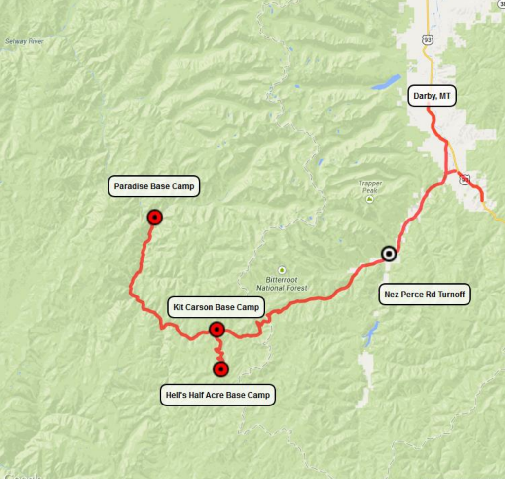
Driving Directions to Cameron Outfitters Base Camps
Here are our base camp directions. The easiest way to access our Base Camps in Idaho is via US 93 in the Bitterroot Valley of Montana. The turnoff is about 75 miles South of Missoula, Montana and 69 miles North of Salmon, Idaho on US 93.
Coming from the North to the Nez Perce Road turnoff
- Go south on US 93 through Darby, Montana 4.4 miles from Darby Post Office and turn right onto the West Fork Rd (Highway #473), just before the West Fork Bridge, if you go over the bridge you have gone too far.
- Travel south 14.4 miles then turn right onto the Nez Perce Road. This turn is about ½ mile past the West Fork Ranger Station. This is the road toward Elk City and is called Magruder Corridor on some Forest Service Maps. Do not continue on the West Fork Road toward Painted Rocks Reservoir.
Coming from the South to the Nez Perce Road turnoff
- Go north on US 93 from Salmon, Idaho about 69 miles. You will travel through the town of North Fork and continue on US 93N up and over the Idaho / Montana divide at Lost Trail Pass. (This is where Lewis and Clark mistook the Bitterroot Mountains for the Continental Divide which is actually up the hill a short ways on MT 43).
- Continue north on US 93 23.6 more miles and turn left at the Conner Cutoff Rd. There is a sign that points to Painted Rocks Reservoir. Go 1.2 miles on Conner Cutoff then turn left on the West Fork Rd # 473.
- Go about 11.3 miles on the West Fork Road then turn right onto the Nez Perce Road. This turn is about ½ mile past the West Fork Ranger Station. This is the road toward Elk City and is called Magruder Corridor or NF-468 on some Forest Service Maps. Do not continue on the West Fork Road toward Painted Rocks Reservoir.
From the Nez Pierce Road to turn off for Hell’s Half Acre Base Camp Directions
- You will travel a total of 24.1 Miles, about 4 miles on pavement and then 6 miles of dirt road. There are several side roads, just stay on the main dirt road. You will pass Fales Flat Camp Ground on the left and the road will again be paved going over the Idaho / Montana Divide.
- Continue on the paved road up and over the divide and down the hill. You will pass Kerlee Creek, Pete Creek, and Half Way Creek before coming to the road to Hell’s Half Acre on the left.
From Hell’s Half turnoff to Hell’s Half Base Camp Directions
- Turn left on to Hell’s Half Road. Camp is 11.8 miles. The road up to the Hell’s Half Acre Camp is a small dirt mountain road. Do not start up this road if you do not have 4 wheel drive vehicle or are pulling a trailer over 16 ft. If you do not have 4 wheel drive please make prior arrangements with us and we will pick you up at the Kit Carson Base Camp. There will be a Storm Creek Outfitters (Cameron Outfitters) sign at the top, turn right and go a couple of hundred feet to the camp.
From Hell’s Half Turnoff to Kit Carson Base Camp Directions
- Continue on the Nez Perce road for .4 miles and turn left at the next road. The camp is only about 200 yards up this road. If you leave the asphalt you have gone too far. We are at the end of the asphalt. There will be a sign on the Nez Perce Road for our camp.
From Hell’s Half Turnoff to Paradise Base Camp Directions
- Drive 10.8 miles (at 7.5 miles there is a road to The Magruder Ranger station, stay to the right and don’t cross the bridge. This also the confluence of Deep Creek and the Selway River)
- At 10.8 miles there will be a fork in the road, stay to the right turning onto Road NF-6223 (this road follows the Selway River, if you cross a bridge and start up a long hill you have gone the wrong way).
- Drive 12 Miles on NF-6223, cross the bridge over White Cap Creek, turn right and go until the end of the road (about .75 miles) into Paradise Base Camp.
Read more about the Selway-Bitterroot Wilderness on the U.S. Forest Service site.